 |
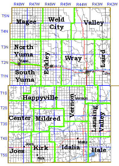
Yuma County, Colorado
1920 Precincts
|
|
|
The precinct boundaries shown in bold green on the following map are those of 1920. Some of the precinct names are still used today although the boundaries have been greatly modified in the last 80 years. The precinct names and locations roughly correspond to the precinct names used in the 1900, 1910 and 1920 Federal Census.
NOTE: While Yuma County was established in 1889, the south one-half of the county wasn't added until 1903. Prior to that it was part of Arapahoe County.
|
 |
| |
The base Yuma County map used for this map was downloaded from the Tiger Mapping Service of the US Census Bureau then the township survey grid and the precinct lines were added. The maps on this page are copyrighted 2000, Lee C Zion e-mail lzion@plains.net, All Rights Reserved.
Go to Yuma County Place Name Table
Go to Yuma County Historical Map
Go to Yuma County Township Map
Go to Yuma County School District Map