 |
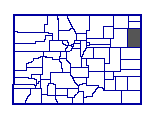
Yuma County, Colorado |
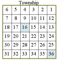
How are sections numbered? Townships 6 miles tall and 6 miles wide are divided into Sections each 1 mile tall and 1 mile wide. Each section contains about 640 acres.
The sections are numbered starting in the northeast corner of the township with section 1 and ending in the southeast corner with section 36.
Sections 16 and 36 of every township in Yuma County were deeded to the State of Colorado when Colorado was formed. Section 16, the school section, was leased to generate funds to support public schools. Section 36 was leased to fund state government operations.
Some other sections and parts of sections were also transferred to state ownership when the state was formed. In Yuma County, those transfers were primarily land in the flood plains along the rivers.
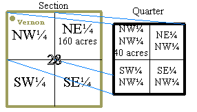
What are Half-Sections, Quarters, 80s, 40s? For the purposes of describing land locations, each section is subdivided into quarter-sections of 160 acres. The "Quarters" are subdivided into forty acre plots known as "40s". While not often used in Yuma County, each "40" can be further subdivided into four 10 acre square plots and the 10 acre plots subdivided into 2½ acre square plots.
A half-section is two adjoining quarter-sections. An "80" is two adjoining 40 acre subdivisions.
To illustrate the system, the "forty" that was deeded by A.J. Miller to the Vernon town council in 1892 for the Vernon townsite was described as the NW¼ NW¼ Section 28, Township 1 South, Range 44 West of the Sixth PM.
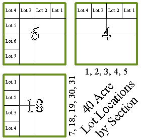
What are Lots? Since the earth is curved and townships were surveyed using the curved lines of latitude and longitude, compromises have to be made to fit in 36 sections, each legally defined as a 5280 foot square. Under the land survey laws all "errors" in section size were pushed into the 11 sections in the northern and western tiers of the township - sections 1-6, 7, 18, 19, 30 and 31. Those sections always contain more or less than 640 acres.
When the local survey was made to establish internal section divisions the same "push the error north and west" rule was applied. In the 11 problem sections the "40"s along the north and west sides of the section are all larger or smaller than 40 acres and are designated "Lots".
The legal description for the northeast quarter of section 4 in the illustration would be "160 acres more or less consisting of Lot 1, Lot 2 and the S½ NE¼ of Section 4".
The land survey rules break down in areas where settlers agreed on land divisions before the surveyor defined the section lines. Ownership maps of the Yuma County townships in Township 5 South along the South Fork of the Republican River reflect, quite dramatically, the original borders in the many odd-shaped and odd-sized numbered lots.
The rules also break down along political boundaries where small lots were created in the quarters along the border. This is reflected in the ownership maps of Range 42 West along the Colorado-Nebraska and Colorado-Kansas border.