Yuma County
Cemeteries |
 |
A listing providing a description and location is below the
map legend.
Clicking on a cemetery name on the map will take you to that entry
in the listing.
Use your browser's Back key to return to the map.
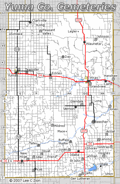
| Map Legend |
Icon |
Meaning |
 Stone |
Cemetery/Grave |
 Stone (gray) |
Memorial Marker |
 Cross |
Location lost to history |
 Circle/Dot |
Town |
 Number in Shield |
US Highway |
 Circled Number |
State Highway |
 Boxed
Character |
County Roads
Black - paved
Gray - gravel |
Cemeteries/Graves/Memorial Markers
For Lookups in any of these cemeteries see the footnotes.
Bios and headstone photos for those from the county who died in the service
of their country are in the Gold Star project.
Links are provided to cemetery listings and tombstone photos. GPS locations
are generally NAD-27.
If you know other links specific to one of the
cemeteries please drop me a note!
Suggest you
bookmark this page before following the links.
- Armel Cemetery
- Community cemetery located three miles north of US 36 at the intersection
of Co Rd 15 & PP. Established in 1905 as a church cemetery it is now
an active public cemetery maintained by the East Yuma County Cemetery
District.
GPS: 39°47'26"N, 102°06'24"W
Colorado
Stones Project - Some headstone photos.
List of veterans burials.
- Beecher's Island Battlefield
- Joint Colorado-Kansas historical site established in 1905 on the 1868
Beecher's Island Battlefield. Located on the west side of Co. Rd KK where
it crosses the Arikaree River. Maintained by the Beecher Island Battle
Memorial Association. Monument and memorial markers for the Forsyth Scouts
who died in the battle.
GPS: 39°52'19"N, 102°11'08"W
Colorado
Stones Project - Photos of the markers.
Yuma County
data index has links to battle details.
The Beecher Island page
of the YCHS
web site has more Beecher photographs and information.
- Bumbley Child Grave
- A son of George and Clara Bumbley died circa 1918 and was buried
on the family property northwest of Wray. Farmstead location and grave
location are unknown today.
- Buffalo Hunter Grave
- This lonely memorial marker and sandstone slab on a hilltop overlooking
the Arikaree on the Wineglass Ranch mark a grave found by the Daniel
Shields family in the early 1880s. The Shields
assumed it must have been a hunter who died in the 1870s. The grave and
a marker placed by the Yuma County Historical Society are
on the hill on the south side of the Arikaree River just east of the
county road that crosses the ranch connecting Roads Z and AA. Photographs
of the marker and the site are in the Colorado
Stones Project.
GPS: 39°44'52"N, 102°21'16"W
- Day Family Graves
- Memorial Marker placed by the Yuma Co Historical Society on
the homestead of Abraham "Happy" Day and his wife Ida (died
1917 & 1915)
both of whom were buried there. The marker is on private property
north of Eckley, a mile north of Co Rd 43 in the NW¼, Sec 27,
T3N R45W, on land owned by the Brophy family. Historical Society volunteers
made a "best
guess" about
the original plot location based on verbal accounts and residue from
wood posts that might have fenced the plots.
Not visited but near GPS: 40°08'58"N, 102°27'09"W
- Delto Family Cemetery
- Abandoned family cemetery on private land in Sec 35, T5S R44W (about
1 mile west of US 385 and 1 mile north of the Kit Carson county line)
established about 1888 by the family of Ernest A. Delto. One marker,
that of Ernest Delto 1847-1888, survives. There were at least three and
perhaps more Delto family burials there.
GPS: 39°35'10"N, 102°16'04"W
- Downey Family Cemetery
- Abandoned family cemetery dating from the 1890s on private property
now owned by the Peters family in Sec 25, T4S R43W. The cemetery is located
about 1/4 mile north of Co Rd 7 and is 6 1/2 miles east of US 385. From
the county road at the old Downey farmstead the cemetery appears to be
a three foot tall foundation in a pasture on the far side of the
field. No surviving markers. Six known Downey and Rolow burials.
GPS: 39°40'46"N, 102°07'44W
Photographs
in the Colorado
Stones Project.
- Eckley Cemetery
- Active public cemetery dating from about 1908 located just south of
US 34 at the town of Eckley. Maintained by the Eckley Cemetery Board.
GPS: 40°06'17"N, 102°29'00"W
Some photographs in the Colorado
Stones Project.
List of veteran
burials
- Friend Cemetery
- Abandoned cemetery located on private land in the NE¼ Sec 30,
T4S R45W. Established before 1890 near the town of Friend and abandoned
by 1905 after a new landowner told family members to move their
loved ones off his land. Many were reburied in the nearby Lucas Memorial
Cemetery. Others were relocated to the Kirk Cemetery. No trace of the
Friend Cemetery remains today and no listing of the original burials
at Friend survives.
- German Lutheran Cemetery,
aka Evangelical
Lutheran Church Cemetery, Landsman Cemetery and Spring Valley Cemetery
- Abandoned church cemetery established in 1890 on land owned by August
Handke, now maintained by the East Yuma County Cemetery District. The
last of twenty known burials was in 1908. The
cemetery is located just north of the Yuma-Kit Carson County line in
the SW¼ Sec 34, T5S R44W on Co Rd 0 (Kit Carson Co Rd RR).
GPS: 39°34'19'N, 102°16'37"W
- Gilstrap Family Cemetery
- Abandoned family cemetery dating from the 1890s. There were at least
a dozen family burials there; the last in 1936. There are a half-dozen
surviving stones. The cemetery is on private property a mile east of
Road PP and a mile south of US 385. One veteran
burial.
GPS: 39°43'57"N, 102°05'03"W
- Glendale Cemetery, aka Vernon Cemetery
- Community cemetery established in 1887 in the SW¼ Sec 7, T1S
R44W two miles east of Vernon on Rd 26 (two miles west of US 385.) Now
maintained by the East Yuma County Cemetery District. Sexton records
for the years before the cemetery district took it over are incomplete.
There are several known unmarked graves.
GPS: 39°56'56"N, 102°16'52"W
Some headstone photos in Colorado
Stones Project
List of veteran burials.
- Grandview Cemetery, aka Wray Cemetery
- Community cemetery on top of the bluff at the south end of Main Street
maintained by the East Yuma County Cemetery District. Grandview was started
in 1885/1886 as the family burial plot for some of the William Dorman
children. Mr. Dorman sold other early Wray residents plots until 1913
when the Grand View Cemetery Association sold stock to purchase the
land. The oldest surviving headstone is that of "Baby Shinabarger" dated
1886. Burial records for the early years are incomplete since the Association
and the City of Wray, after the city took it over in the late 1920s,
recorded only plot ownership.
GPS: 40°04'02"N, 102°12'47"W
Some headstone photos in Colorado
Stones Project.
List of veteran burials.
- Hanshaw Cemetery, aka Lakeside Cemetery
aka Laird Cemetery
- Now a public cemetery maintained by the East Yuma County Cemetery District,
the Hanshaw cemetery was created in 1919 by Edward Hanshaw
as a family plot for the burial of his daughter Nellie. Edward was buried
there in 1937. The Hanshaw family deeded the land to the cemetery district
in 1979 for use as a public cemetery. Lee had the cemetery as northeast
of Laird on the east side of Rd RR in Sec 34, T2N R42W.
GPS: 40°05'27"N, 102°03'22"W.
-
- But GoogleMaps has it on Rd SS. From Hwy 34 east of Laird take County
Road Railroad north, following it east and then north on SS.
-
Two veteran burials.
- Idler Family Cemetery
- Family cemetery on private land started in 1896 by Gotthlif
and Catherine Idler as the resting place for seven of their children
who died that summer of diphtheria. Catherine (died 1924), Gotthlif
(died 1942) and a son who died in 1975 are also buried there. North
of Kirk on Rd M, and then west ½ mile on Rd 7. Maintained by
the Idler Family. Yuma Pioneer story
GPS: 39°40'18"N, 102°35'44"W
- Joes Mennonite Church Cemetery
- See New Hope Mennonite Cemetery
- Johnson Family Cemetery, aka Wauneta Cemetery and Triangle
Cemetery
- Family Cemetery five miles northeast of Wauneta on Rd 51 started
in 1921 by C.H. Johnson as the burial place for his son, Blufford Randy
Johnson. One other known child burial. In Sec 21, T4N R43W. Maintained
by the landowner.
GPS: 40°18'26"N, 102°10'12"W.
- Jones Family Cemetery
- The Bob Jones Family Cemetery is located on a hilltop
on private land on the Jones Ranch just east of Rd RR north of the
Arikaree River. Created in 1991 as the resting place for Robert "Bob" Jones
who wanted to be buried on his ranch. His wife was buried there in 2003.
Maintained by the Jones family.
GPS: 39°56'08"N, 102°04'55"W
- Kingston Cemetery
- See Lansing Cemetery
- Kirk Cemetery
- Public cemetery located a mile south and a half-mile west of Kirk on
the north side of Rd 2 in Sec 23, T5S R47W. The first known burial was
in 1892. It is maintained by the Kirk Cemetery District.
GPS: 39°35'57"N, 102°36'00"W.
Some stone photographs in the Colorado
Stones Project.
Derrill Langen's transcription is on GeoCities.
List of Veteran burials.
- Lakeview Cemetery
- See Hanshaw Family Cemetery
- Landsman Cemetery
- See German Lutheran Cemetery
- Lansing Cemetery, aka Kingston Cemetery and Lansing Valley Cemetery
- Abandoned community cemetery in SW¼ Sec 26 T3S R43W on the east side
of the Beecher Island Road (Rd LL) 1½ miles north of US 36. The
first known burial at Lansing was in 1887 and the last in 1942. It is
now maintained as an inactive cemetery by the East Yuma County Cemetery
District.
GPS: 39°46'03"N, 102°09'47"W
Photographic survey in Colorado
Stones Project.
- Lagler Grave
- Burial plot on the family farm for a child of Fred and Julia Lagler.
On private land in the SE¼ Sec 4, T4N R44S a mile south of Rd
54 and 1½ miles
west of US 385. No trace remains.
- Long Infant Grave
- Circa 1912 grave of infant child of Simon Long. Described as located
2 miles east and 1¼ miles south of Clarkville. No trace remains
today.
- Long Family Cemetery, aka Dolly Long Grave
- This 1890s family plot on the homestead of John and Sarah (Foreman)
Long is about six miles east of Vernon located just south of Rd 27
between Rds HH
& JJ in the NE¼ Sec 20, T1S R43W. The abandoned cemetery on
private land is the final resting place for at least five members of
the John Long family who died between 1893 and 1900. Two headstones survive.
GPS: 39°57'42"N, 102°12'45"W
Photographs in Colorado
Stones Project.
Transcription in the USGenWeb
Archives.
- Lucas Memorial Cemetery
- Public cemetery established in 1901 by Andrew Lucas and deeded to
the community. Now maintained by the East Yuma County Cemetery District.
The Lucas Cemetery is located a half mile north of U.S. 36 on the west
side of Rd. AA in Sec 13, T4S R45W. Mr. Lucas created this cemetery on
his homestead to provide a new home for
those who had been buried at the Friend Cemetery. The first graves with
headstones dated earlier than 1901 in the Lucas Cemetery are those moved
from Friend and reinterred.
GPS: 39°42'35"N, 102°20'56"W
Some stone photographs in Colorado
Stones Project.
Transcription in the USGenWeb
Archives.
List of veteran burials.
- Mace Family Graves
- James and Nancy Mace had 480 acres of land on today's
Rd Z where it crosses the ridge between the Copper Kettle and the Arikaree.
When James died in 1908 and Nancy followed in 1913 the obits led
the reader to believe they were returned to the Mace ranch for burial. No
trace of their graves has been found but they are not listed in any of
the local cemetery burial records.
- Mildred Cemetery
- Abandoned community cemetery dating from 1912 on the west side of Rd
U a mile south of the Rd 20 intersection. The cemetery is on State
Land in Sec 36, T2S R46W and is maintained today by the Leo Prather family.
Abandoned about 1932 the cemetery was adopted 40 years later by the
Mildred club and restored. While there were only a couple of surviving
original headstones, the club identified at least 16 burials and placed
plot markers where graves could be identified.
GPS: 39°50'45"N, 102°27'54"W
Mildred Club listing from 1972 is in the USGenWeb
Archives.
One veteran burial.
- New Hope Mennonite Church Cemetery aka
Joes Mennonite Cemetery
- Cemetery established in 1896 across the road east of the Mennonite
Church and still in use. On the north side of US 36 at Rd J it is in
the SW¼ Sec
33 T4S R47W. The church building is now the home of the Liberty
Baptist Church.
GPS: 39°30'40"N, 102°38'56"W
A few stone photographs are in Colorado
Stones Project.
List of veteran burials.
- Olivet Nazarene Church Cemetery
- Church cemetery established in 1915 just east of the intersection
of Rds P and 9, north of Kirk. The Nazarene Church building was moved
to Kirk several years ago but the cemetery is still active. In NW¼ Sec
20 T4S R46W.
GPS: 39°42'00"N, 102°33'14"W
Some stone photographs in Colorado
Stones Project.
List of veteran burials.
- Oman Grave
- Abandoned grave on private land in the SW¼ Sec 30 T4S R43W
of Mrs. Chris Oman and her baby son on the family land 1¼ miles east
of US 385 on Rd 7. Dating from "the pioneer days" no trace remains today.
- Pleasant Valley Cemetery
- Church and community cemetery southeast of Clarkville established in
1909 a quarter mile north of the Pleasant Valley Church and still in
use. The cemetery is in the SW¼ Sec 6 T4N R46W on the east side of Rd
P north of Rd 53.
GPS: 40°20'29"N, 102°33'54"W.
Some headstone photos in
Colorado
Stones Project.
List of veteran burials.
- Shores Family Graves
- Family cemetery for Robert Shores, his wife and two of their children.
Located "1 mile north and ½ mile east of the US 36/US 385 junction" in
the SE¼ Sec 12 T4S R44W. No trace remains today.
- Spring Valley Cemetery
- See German Lutheran Cemetery
- Saint Johns Evangelical Cemetery
- Church cemetery southeast of Idalia established in 1887 and still in
use. Located a half-mile west of US 385 on the south side of Rd 7 across
from St Johns Church. The cemetery is in Sec 35 T4S R44W.
GPS: 39°40'24"N 102°15'40"W
Some headstone photos in
Colorado
Stones Project.
List of veteran burials.
- Schlake Cemetery
- Family/community cemetery established about 1900 and abandoned before
1930. There were about 20 known burials. This is another cemetery
where a new landowner told surviving
family to move their loved ones off his land. It is not known how many
graves were left when the cemetery was farmed over.
The cemetery was somewhere on the quarter section at the northeast corner
of the intersection of Rds C and 52 in the SW¼ Sec
8 T4N R48W on land settled by William Schlake. No trace remains today
but oral history places it near one of the roads.
Perhaps near GPS: 40°19'18"N, 102°46'25"W.
- Talley Grave
- Memorial marker near the Arikaree on the Thompson Ranch. Marker was
placed to mark the site of Frank Talley's 1880's
burial. According to accounts, Talley was a cattle buyer who was known
to carry a large amount
of money to fund his purchases. He was murdered and robbed as he traveled
to visit ranchers in the Arikaree River valley. His remains were later
discovered by ranch hands who buried him where he was found. Almost a
hundred years later volunteers led by Leo McCoy placed a gray granite marker
made by Ralph Spellman near the site described
by oral history. To get to the ranch from US 36, go north six miles on
Rd P and follow the private ranch road a half mile southwest to the ranch
headquarters. The memorial marker is on the south bank of river another third
mile west. The marker is in the vicinity of GPS 39°44'17"W,
102°34'17" in
the NW¼ Sec 6 T4S R46W.
- Triangle Cemetery
- See Johnson Family Cemetery
- Unknown Grave
- On private land three miles southeast of Hale in Sec 29 T5S R42W on
the USGS Bonny quadrangle map there is a grave symbol. That is all
that is known about this burial location.
GPS 39°35'52"N, 102°05'32"W.
.
- Vernon Cemetery
- See Glendale Cemetery
- Wauneta Cemetery
- See Johnson Family
- Wray Cemetery
- See Grandview Cemetery
- Yuma Cemetery
- Public cemetery on Rd 39 at the intersection with Rd G a mile east
of Highway 59 in the SE¼ Sec 14 T2N R48W. The Yuma Cemetery was
established in 1888 and is still in use maintained by the Yuma Cemetery
Board.
GPS: 40°08'04"N, 102°05'32"W
Sexton records are in the Colorado
USGenWeb Archives.
Some tombstone photographs are in
Colorado
Stones Project.
List of veteran burials.
- Yuma Railroad Teamster Memorial Marker
- Marker placed by Yuma residents at the Colorado Historical Society
'Welcome to Colorado and Yuma County' historical marker and parking
area three miles east of Yuma on the north side of US 34 at Rd J.
The marker recognizes an unknown 'Yuma Indian teamster' killed in an
early 1880s railroad construction accident and buried somewhere along
the Burlington, Missouri and Colorado Railroad tracks east of Yuma. According
local legend this unknown Indian teamster was the namesake of the later
Town of Yuma, Yuma County and the current Yuma Indians school sports
teams.
- Footnote:
- I have a copy of both Pat Oestman's "Burials in Yuma County 1992" and
Aileen Tombaugh's "Yuma County Cemeteries" printed in 1993. I
am willing to do lookups in both. Send an email to Lee Zion (lzion@plains.net)
Subject: Yuma County Cemeteries
This page copyrighted 2008, Lee C Zion; e-mail:
lzion@plains.net, All Rights Reserved