Yuma
County, Colorado
History

Yuma
County, Colorado |
|
|
email
mdmonk2@tx.rr.com |
Yuma County, straddling the 40th parallel on the eastern edge of Colorado, was a relatively late addition to the Colorado map. While archeological digs in the county show that mankind has occupied the county since prehistoric times, the first "American" settlers didn't move into the county until after 1870. The first explorers, traveling through the high plains area in a drought period, labeled the area the "Great American Desert." The Oregon Trail passed to the north following the Platte River. The Santa Fe Trail passed far to the south along the Arkansas River. The land along both rivers was settled early in Colorado history. The land between the two rivers remained a hunting ground used by several American Indian tribes.
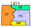
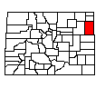
Originally claimed by Spain, what is now Yuma County was part of the land the young United States acquired from France in the 1803 Louisiana Purchase. In 1805, it was included in the newly founded Louisiana Territory. It was part of the original 1812 Missouri Territory and was designated unorganized US territory in 1821 when Missouri became a State. The 1854 Kansas-Nebraska Act, split what is now Yuma County between Nebraska Territory and Kansas Territory along the 40th parallel. (The area covered by the following Northeast Colorado maps is shown outlined in red.)
The discovery of gold in the Colorado Rockies in 1858 brought a large influx of people to Colorado and led to the 1861 establishment of Colorado Territory. However, the high plains remained an Indian hunting ground until about 1870. Conflicts between the Indians and the new residents spreading out from the Front Range and with travelers on the trails to the gold camps in the mountains lead the US Army and the Colorado Militia to force the tribes out of Eastern Colorado onto reservations in Oklahoma and Wyoming in 1870.
When Colorado Territory was created by Congress in 1861, northeastern Colorado was split between Weld and Arapahoe Counties along the 40th parallel. What is now Yuma County was split in half; Weld County to the north and Arapahoe County to the south. Both of the new counties stretched from Denver to the Kansas-Nebraska border. The land in eastern Colorado south of the Platte and north of the Arkansas remained mostly unoccupied. (The area covered by today's Yuma County is outlined in green.)
After the Civil War, settlement in western Kansas forced Texas cattle herds driven north to market further and further west. About 1870, cattle trails were established through Eastern Colorado to the Union Pacific railroad at Ogallala, Nebraska and to markets further north in Wyoming, Dakota and Montana. Ranchers recognizing the value of the high plains grasslands established holding and fattening areas in what is now Yuma County that soon developed into large ranches occupying both private and public lands. Ranching was the only industry in the local area when Colorado became a state in 1876.
The Burlington and Missouri (later the Chicago, Burlington and Quincy) railroad completed a mainline to Denver in 1882 through the middle of what would become Yuma County. Land and townsites along the new rail line were promoted worldwide to potential settlers in an effort to establish a base of customers for the new rail line. Then in 1885, the President directed that illegal ranch fences be removed from public lands forcing the large ranches off public lands and opening them to homesteaders. Real Yuma County settlement dates from those two events.
The McCook Tribune of November 12, 1885 said "Eight buffalo were killed near Eckley, the first of last week, a portion of which were shipped to this city and disposed of by our local butchers. Considering the great scarcity of that noble game, but a few years since so numerous in the Republican Valley, the hunt which resulted in the bagging of eight bison was an unusually successful one."
By 1887, the population of eastern Weld County was large enough for voters to demand a split into new counties. The original Weld County was split roughly in half. The southeastern corner became Washington County with the county seat designated as Akron. The northeastern corner became Logan County with the county seat designated as Sterling.
Two years later in 1889, Washington County was divided in half and Yuma County [shown in yellow] was created with the County seat in Yuma. The southern portion of today's Yuma County remained in Arapahoe County. In the same year, Logan County was divided in half to create Sedgwick [orange] and Phillips [violet] Counties. Morgan County [dark brown] was formed from the southeast corner of Weld County. Arapahoe County remained stretching from Denver to the Kansas border.
The 1890 census counted 2594 people in Yuma County, 2305 in Washington, 2665 in Phillips, 1297 in Sedgwick, and 8048 in Logan, as listed in a July 24, 1890 article.
The Colorado Legislature divided Arapahoe County east to west in 1901 to form Adams County [brown]. The new Adams County was just as wide as Arapahoe County and voters in the eastern part both counties objected to having to travel so far to the county seats located in Denver and Brighton. Also in 1901 Denver County was created but that act was rejected by the Colorado Supreme Court.
In 1902, after a twelve year political battle, two-thirds of Yuma County voters chose to move the Yuma County seat to Wray.
The 1902 legislature rewrote the 1901 acts and reorganized Arapahoe and Adams Counties. The eastern portions of both were added to Washington and Yuma Counties in 1903, doubling their size. The City and County of Denver was carved out of western Arapahoe County. These changes were the final changes to the county borders of northeastern Colorado map until 2001 when the City and County of Broomfield was created.
Those political county boundary changes are only part of the story. The mid-1880's demise of the large open range ranches was also driven by two years of record snow, blizzards and record low temperatures. Many ranchers lost three-fourths of their stock in the winter of 1885-1886 alone.
Many of the 1880s settlers moved back east or on west after several years of drought in the 1890s.
Miss Alary Elmore taught the first school at Yuma, in 1886.
By 1890 there had been built in Yuma, Wray, and in the other towns of the county twenty-two schoolhouses, with an enrollment of 573. In the county high school at Wray the enrollment January 1916, was 107, with 2,816 enrolled in the 109 schoolhouses of the county. The valuation of school property on January 1, 1916, was $54,899.
THE DROUGHT IN YUMA COUNTY
"This [a drought] of course made many people leave Yuma County. They left in any way that they possibly could. Many left by train, others packed and walked out. Horses, cattle and hogs were turned loose to roam the plains at their own will. The river was almost dried up and all the lakes and ponds in the county were about dried away. . . . In 1890 there were about 2600 people in Yuma County and in 1900 there were only a few over 1700. This famine if it may be called was a boon to the dry country of the west because it helped to develop new methods in tilling the soil. New tools were made and different ways developed so that the farmer could make money out of the dry soil."
Source: J. Oliver Graham (1934), CWA Interviews Doc. 352/3, Colorado Historical Society.
The early 1900s brought more settlers only to see them chased off the land by the hard times of the great depression and the drought years. The automobile forecast the end of the local general store. By the middle of the 1950s most of the small community businesses had closed their doors in favor of the larger towns. The traditional small family farm and ranch died a slow death in the period 1950-1980.
Today's Yuma County remains true to its heritage. It is primarily agricultural. Land use is divided almost evenly between ranching and farming. Yuma County measures 60 miles north to south and 40 miles east to west. The 2010 population was 10,043, down from the 1920 census high of 13,897.
Need exact dates of any of these events? See the Colorado County Chronology in Colorado Places by County.