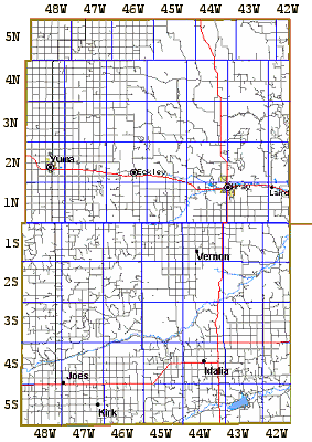
Yuma County, Colorado
Original Land Patents
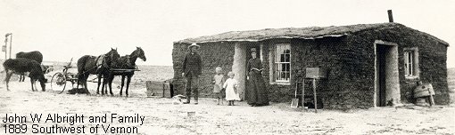
This 1889 photograph shows a typical Yuma County homestead.
Pictured are the John W. Albright family standing in front of their sod
home five miles west and 2 miles south of Vernon in the SW¼, Section
34, Township 1 South, Range 45 West. Mr. Albright, one of the first settlers
in the Vernon area, "proved up" his claim for the quarter and his homestead
act patent was signed December 11, 1891. He also had a timber claim in
the NW¼, Section 20, Township 2 South, Range 45 West patented in 1900.
We compiled land patent information from the Bureau of Land
Management (BLM), General Land
Office, Land Patent Database to make township tract maps depicting
the original land owner and the year of the patent along with showing
today's road network..
The tract maps are in Adobe Acrobat Portable Document Format
(PDF). To view and print the maps you must have a copy of the
Acrobat
Reader™. These maps are not viewable by WebTV
visitors.
The index map and the table below are "click-able". To download and
view a township map click on the target township in the index map or
use the township link in the table. These township map plates are sized
to print on standard 8½ x
11 paper at 300 dpi.
There is a By Name Index ( A-C |
D-F | G-K |
L-O | P-S |
T-Z ) for the land patent maps. Each
township plate also has an included index page with errata
notes to aid in locating the patents within that township. No attempt was
made to duplicate all the information found in the BLM database.
The township plates show most of the current Yuma County road network
to help locate the patents on modern maps. While each of the plates is
sized to print on 8x11 paper, they are not all sized to the same printed
scale so you won't be able to trim the margins and tape them edge
to edge to create a larger county map as you could with the "1976
Vernon Area Centennial" map sections.
Lee created a blank township map (24kb PDF) with
the sections subdivided into '40s' to aid in plotting land ownership from the
legal descriptions. You are welcome to download it and print it to use for your
own research.
Land Patent Dates:
The dates of the patents in the BLM database and the year of the patents
shown on these maps reflect the date the signed final patent document was
issued by a clerk in the Department of Interior in Washington D.C. and
not the day the settler "proved" his claim at his local land office
and became the owner. During most of the time period
covered by these patent maps, the final patent document was signed for
the President and mailed from Washington D.C. about a year after the settler
had finalized his claim at the local land office.
Common Land Patent Types:
Land cost and fee structures quoted below are those of the 1890s and varied
over the years. Homesteading in Colorado under all of these land patent acts
except cash sales ended before 1935.
- Cash Sale
- The basic federal land sale law established in 1820 provided only for
cash sale of government land. The land claimant filed an "Entry" with
the land office ($3.00 fee), lived on a selected quarter of land, made
improvements and after six months could purchase the land for as little
as $1.25 an acre. That amounted to a total outlay of $200 for a 160 acre
quarter section. The cash price of the land varied by location and better
land cost much more. In other areas cash land sales were done by land
office auction or "over the counter" with no requirement for residency.
The amount of land a settler could purchase varied over the years as
did the "residency"
requirement. After 1890 cash sales were limited to 320 total
acres of all types per person.
- Pre-Emption (a type of cash sale)
- The source of the local use of the term "pre-emption" to describe all
federal cash land sales is unknown. Under the federal land law, pre-emption was
a special term used to recognize that many people had settled on federal lands
prior to the original government survey and opening the area to settlement.
Those pioneer settlers (often labeled "squatters") had a firm right, preempting
all other claims, to purchase the land they had been living on. Their cash sale
patents had a hand written or stamped notation "Pre-emption" to indicate the
special circumstances of the transfer.
- Scrip or by Nature of Scrip
- There were several patents issued in Yuma County citing an 1842 Act
of Congress dealing with "Scrip or by Nature of Scrip" So what the heck
was
"Scrip?" My first thought was that the law dealt with private banknotes,
but that proved to be wrong. In general terms the documents recognized
by the 1842 act were certificates issued by the various levels of government
that could be used to claim land. Examples are Federal and State Land Bounty
warrants (an enlistment and service bonus issued to volunteers in the Revolution,
the War of 1812 and the Mexican War) and Land Scrip issued by the various
General Land Office areas when cash land sales were oversubscribed. There
were other forms of "land scrip." Many were converted to cash by selling
them to speculators shortly after they were issued; others were passed
on in the family for years before they were finally redeemed.
- Note: Land certificates, scrip and land grants issued by foreign governments,
i.e. France, Spain and Mexico, were handled
under the "Private Land Claim" laws not the
1842 Scrip act.
- Homestead
- Under the Homestead Act of 1862 a settler could claim up to 160 acres
of empty federal land simply by going to the local land office, filing
an "intent"
with a $16.00 fee ($3.00 for veterans) and establishing permanent residence
on the land within six months of the filing. After making the necessary
improvements (building a house), establishing the required crop acres (usually
40), and living on the land five years, the settler visited the land office
with his witnesses and "proved up." A $6.00 commission was charged (to
swear and interview the settler and his witnesses) and after a public notice
of the pending transfer the land patent was issued. The five year
residence requirement was later loosened a bit requiring the settler to
actually live on the land for only three years. In 1909 the Homestead Act
was amended to provide 320 acre homesteads.
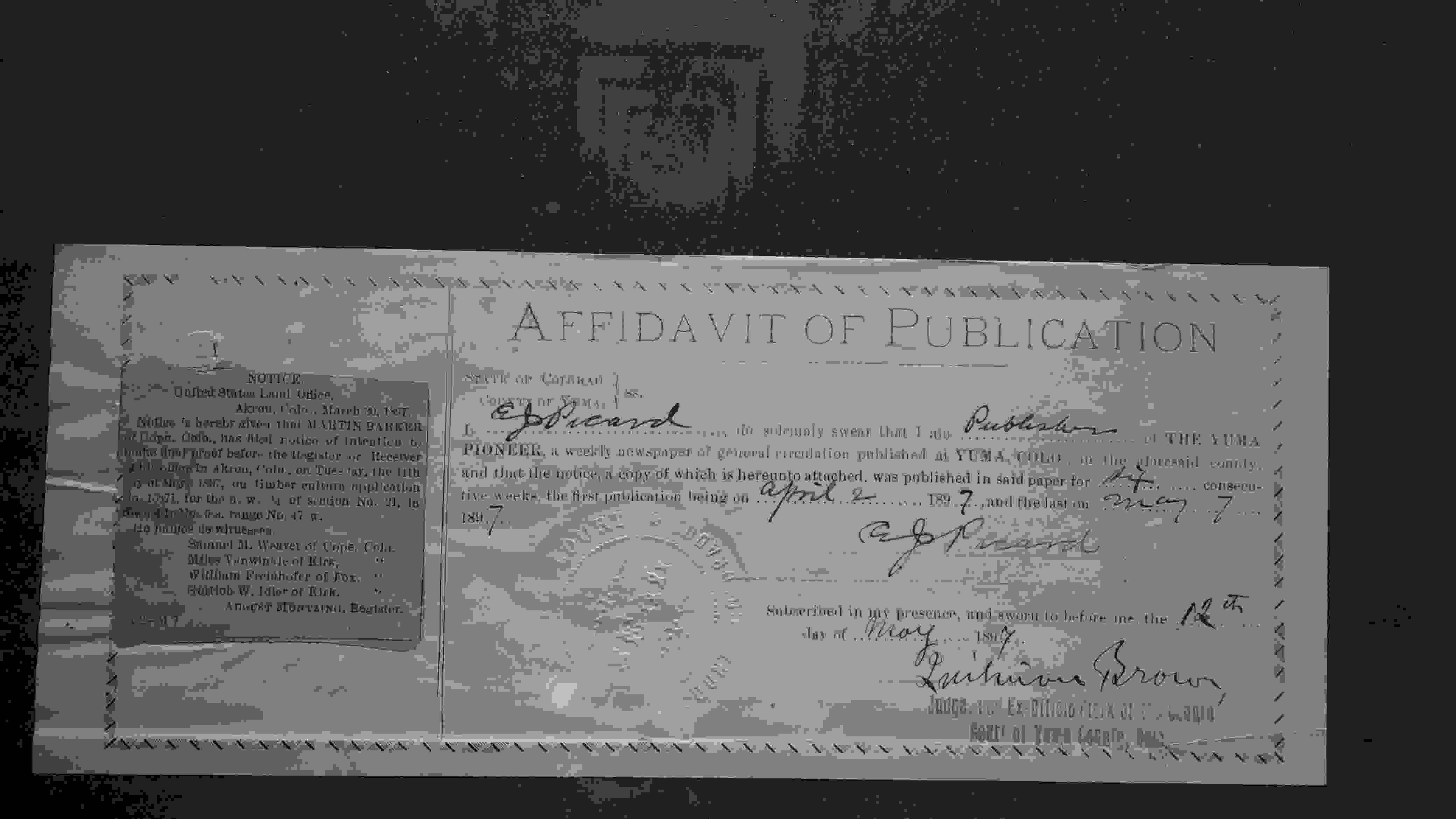
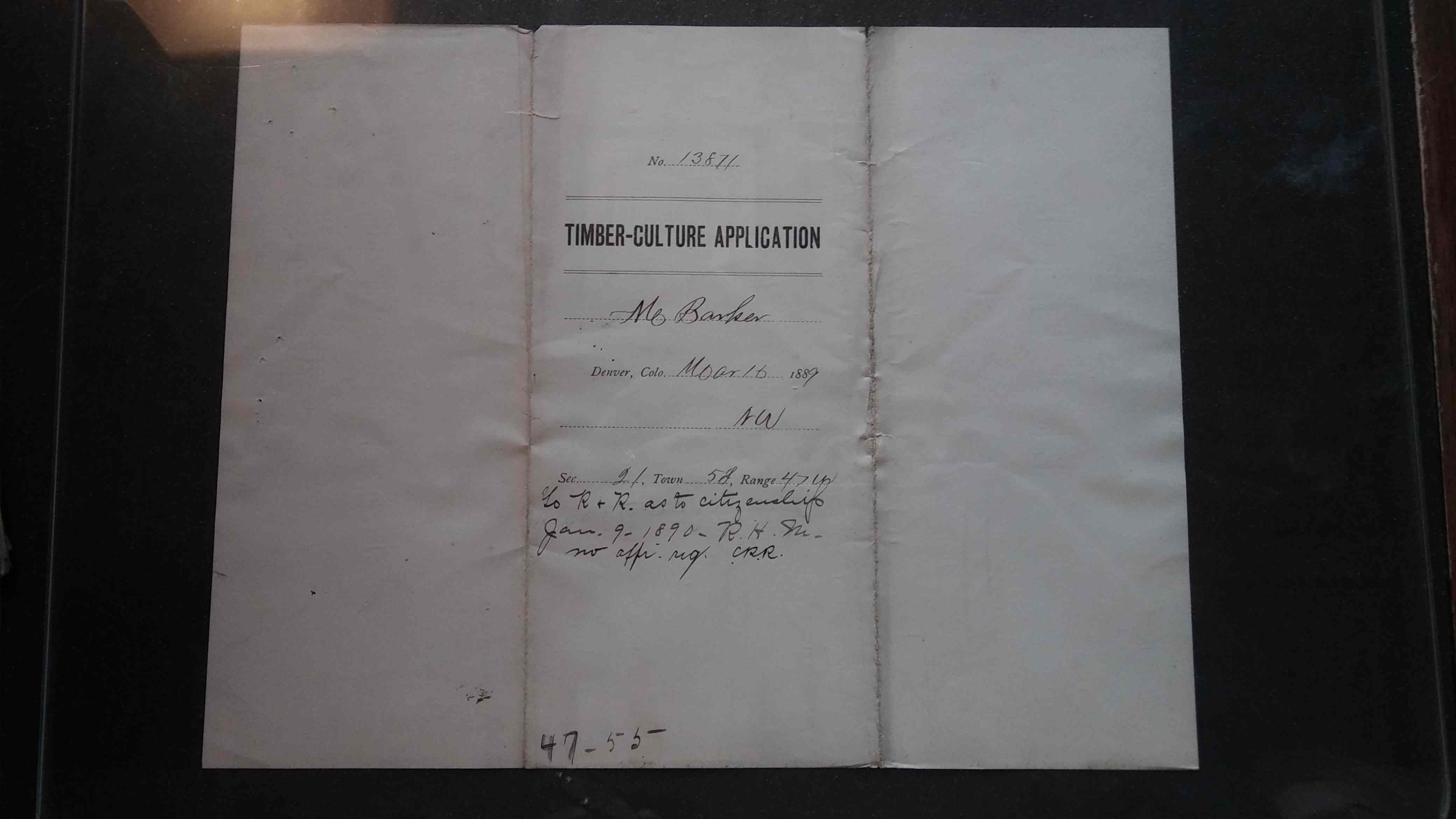
- Timber Culture
- When the high plains was originally settled the few native trees were
all located along the streams. Settlers could claim up to 160 acres of
open federal land under the 1873 Timber Culture Act by establishing a
wood lot on 10 acres of the quarter section of land. There was no requirement
to live on the land. The filing fee for the "intent" was $14.00. During
the first year, the settler had to break out five acres of sod and prepare
it for a crop. In the second year he was required to plant the first
five acres to a crop and break out an additional five acres of sod. In
the third year he planted the first five acres with trees and the second
five to a crop. In the fourth year the last five acres were planted
to trees. There was a long list of "approved" tree types
that could be used but the settler had to plant 2,700 trees and when he
proved his claim his ten acre wood lot had to have 675 established trees.
Trees had to be four years old to be considered established so it normally
required a minimum of eight years work to "prove up" a timber claim.
If drought killed the tree seedlings the time period to meet the requirements
could be extended up to 14 years from the date of the original intent.
(As an exception, during the widespread drought of the early 1890s the
BLM waived the number of established trees as long as the owner had met
the time and acre requirement.)
- Desert Land Irrigation
- There were a few Yuma County patents filed under the 1877 Desert Land
Irrigation (Reclamation) Act. This was a form of cash sale that didn't
prove popular. A settler could claim up to a half section of open federal
land by paying $0.25 per acre up front, diverting surface water to the
land within three years of the "entry" and using the water to irrigate
1/8th of the total acres claimed. When the settler proved up the claim
he had to pay an additional $1.00 per acre.
- Livestock Raising
- Western congressmen added the 1916 Stock Rasing Act to the 1862 homestead
land laws. By the 1920s, settlers could claim up to 320 acres of open
federal land by making improvements, putting the land to beneficial use
for a number of years as a part of their ranching operation and paying
the per acre fee when proving up. Many 1920s Yuma County patents were
issued under the act.
A settler could acquire land under all of the acts. Editorial advice in
local newspapers in the 1890s (before the livestock act and before the expansion of
the homestead act to 320 acres) suggested prospective settlers start with a
"pre-emption" and a "timber claim" both filed the first year on the land. In
the second year (after finalizing the cash sale) the settler would file the
intent on his "homestead." After only eight years he would be the proud owner
of 480 acres of federal land with a total cash outlay of under 50¢ per
acre.
All US citizens (defined as single men and single women over 21, and
all married men regardless of age) were eligible. Married women could not
file an original intent but could "prove up" a claim dating from prior to her
marriage. Each person was eligible for only one "homestead" and one "timber
culture" patent in their lifetime although they could "relinquish" or transfer
their claim to another eligible person and re-establish their rights. They
could also move from one area to another and transfer the time of residence
from the original claim to the new claim.
In 1902, U.S. Congressman from Nebraska's 6th District Moses P. Kinkaid introduced legislation that enlarged a homestead from the 160 acres per the Homestead Act to 640 acres in just thirty-seven northwestern Nebraska counties. Kinkaid originally tried to get more land into the act, but Congress representatives from the crowded eastern states couldn't fathom why anyone would need so much space.
The intent of the act was to give both farmers and ranchers more of a chance to be productive in the relatively arid Sandhills. Land that could be irrigated was exempt from the law, because people would pay real money for those acres. President Theodore Roosevelt signed the bill into law on April 28, 1904.a
People who took homesteads under the Kinkaid Act were known as Kinkaiders, and there were quite a few of them. From the time the bill was signed until 1917, over nine million acres were distributed. That figured out to be roughly 14,000 individual claims.
It is difficult to gauge the effect of the Kinkaid Act accurately. Much of Nebraska's Sandhills region was unsuited for farming, and 640 acres was not a large enough piece of land to ranch successfully. Farmers who claimed land through the Kinkaid Act mostly failed, due to the arid dune topography of the affected land. Ranchers, however, profited by taking over land that the homesteaders abandoned.
|
---------------------------
Date of Settlement:
- With the land patent information it is possible to establish a probable
year of the settlers original arrival on the land without having to request a
copy of the original land office patent file from the National Archives.
- A few examples:
- o An 1888 "cash sale" patent would reflect an arrival date about 18 months
prior to the patent date.
- o An 1895 "homestead act" patent date would date to an intent filed in
1889.
(1895 minus the 1 year patent delay minus the 5 year residence =
1889)
- o A 1900 "timber claim" would date to an intent filed in 1891 or earlier.
(1900 minus the 1 year patent turnaround minus the eight year minimum =
1891)
---------------------------
Using the Maps
When you view these maps you need to remember what they don't show.
They don't show your ancestor in context with his neighboring landowners since
land with 1882 patents joins land with patents issued 50 years later in the
1930s. They don't show land sold by the state. The maps also don't show the extent of any individual landowner's
holdings. For answers to those questions you need to consult a standard
ownership map of the period.
Return to the Yuma County Data Page.
You might also want to look at the 1922
Standard Atlas of Yuma County which has land ownership plates for
every township in the county.