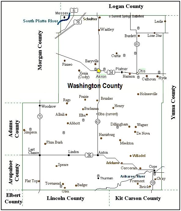
Washington County, Colorado Washington County Colorado Ancestry


Washington County Map and Place Name Directory


Map Legend
Towns Yellow - Statutory towns (Akron and Otis)
Black - Unincorporated towns
Brown - Old post offices and abandoned townsites
Roads Red - US Highways / Interstate
Black - Colorado Highways
Rivers Blue - South Platte (near Messex) and the Arikaree (near Cope)
Cemeteries Green - Black box with cross shows location


Gazetteer for the Historical Map

Abbott
Rural post office that operated from 1887 to 1926 north of Lindon. The location shown on my map is from maps published 1906-1947. The US Post Office archives place the first Abbott six miles southwest very near the cemetery.

Abbott Cemetery
The Abbott church cemetery was established in 1913 and is still in use.

Akron
A Burlington & Missouri River construction campsite later to become Akron was platted in 1882 by the Lincoln Land Company in the NE� of Sec 8, T2N, R52W. The Akron Post Office was established 20 Jan 1883 with George E. Bragg as its first postmaster. Akron has been the countyseat of Washington County since 1887.

Akron Cemetery
The first Akron town cemetery was established in 1886 south of the railroad. It was later moved to its present location one mile west of town at latitude 40.16�, longitude 103.23�W. The cemetery records are maintained by the Akron Town Clerk.

Alkali
Shown on county map in Atlas of Colorado Ghost Towns but nothing else is known.

Anton
Small community at the intersection of Colorado Hwy 63 and US Hwy 36, 23 miles south of Akron. The Anton post office opened in 1916 and is still in operation.

Arickaree
Arickaree* moved twice after the post office opened in 1888 east of Thurman on the north bank of the Arikaree River. The first move in 1920 was up to the corner of what is now US Hwy 36 and Road LL as shown on the map. In 1941 it moved a few miles further northeast where it remained until the post office closed in 1961.

*Arickaree was named for the Arikaree River but the Postmaster General "corrected" the spelling.

Badger
Rural post office west of Thurman in operation from 1890 to 1894.

Brick
Not much is known about Brick. It is shown south of Cope on an undated early map.

Brick Cemetery
A single-grave cemetery in the NW�, Sec 27, Twp 4N, R 54W - "Bird, James" Baby, date unknown

Brunker
Rural post office that operated from 1907 to 1917 about 12 miles south of Akron. The name is a variation of the name of the postmaster, James Brukher.

Burdett
Rural post office north of Otis that operated from 1888 to 1937. Named for William Burdett who settled on Rock Creek in 1870.

Burdett Cemetery
The Burdett cemetery was established in 1893 on land donated by the Preston family. It is still in use.

Calhoun
Railroad siding between Otis and Hyde.

Cody
This may be another name for the Xenia camp on the Burlington line. It was shown on an 1895 Colorado map very near the later-named Xenia camp but the "Xenia" name was not shown.

Cope
Small town on US Hwy 36 in southeast Washington County. The Cope post office was established in 1889 and is still in operation. Cope was named for Jonathan Cope who, in 1887, established a "tree claim" (he painted trees surrounding his claim) on the land where the town now stands. The "Cope Grove", was used for picnics and camp meetings for years thereafter.

Cope Cemetery
A cemetery south of the town on Highway 59. It was established in 1889 on land donated by E.E. Brown and is still in use.

Note: The Cope cemetery is actually located on the north side of highway 59 overlooking the river. I didn't have room on the map to place the icon there. - Lee Zion

Corcoran
Rural post office west of Cope that operated from 1889 to 1894.

County Line (not shown on map)
A stop on the old Akron-Brush road (today's County Road 40) at the Washington-Morgan county line.

Curtis
 Curtis was a post office that operated from 1888 to 1901. It was named for John Curtis, the first postmaster.
  The location shown on the map above "is from maps published from 1890 to 1906 by the US Post Office" - Lee Zion, original Washington County Coordinator.
  Another location from the Roadside Thoughts website is given as 5 miles N, 6 miles E of Akron at the current county roads intersection of 46/JJ (40.2�N,103.1�W). - http://roadsidethoughts.com/co/curtis-xx-washington-map.htm, Jon Hall webmaster. He got his information from an 1895 Rand McNally atlas. He notes that:  "While the community of Curtis no longer exists, we have placed [it on] the map in the general vicinity of where it might of have been found".

Curtis Cemetery
  Curtis Cemetery was established in 1894 on land donated to the local Lutheran church by the Godfrey Gehrig family for his burial. It was in use until at least 1919. The church has burned and many original markers are missing.
  According to the USGS Geographic Names Information System (GNIS) the cemetery is located at the current county roads intersection 48/LL, 2 miles E and 2 miles N (40.27�N, 103.06�W) of the Curtis Post Office location.
  On the Find-A-Grave website http://www.findagrave.com/cgi-bin/fg.cgi?page=gsr&GScid=57236 Cindy Seifert Cooper has memorialized 10 interments: Diamond, Jane b. Mar., 1899 d. Dec. 3, 1900; Gehrig, Careline "Carrie" b. 1830 d. Dec. 10, 1899; Gehrig, Godfrey b. 1819 d. Dec. 27, 1894; Karlson, Anna Maria b. Dec., 1829 d. 1919; Marschang, b. 1909 d. 1910; Meenan, Etta b. 1891 d. Nov. 30, 1900; Meenan, Frankie b. 1896 d. Nov., 1900; Meenan, Joe b. 1877 d. Dec. 4, 1900; Meenan, Joseph b. Aug., 1866 d. Apr. 3, 1903; Meenan, Margaret b. 1821 d. Feb. 6, 1907.

Daily/Rominger Cemetery (not shown on map)
The graves of three babies, no dates or names, located in SE�, Sec 21, Twp4N, R52W - Colorado Genealogical Society listing

De Nova
Rural post office that operated from 1915 to 1955 15 miles NNW of Cope at latitude 39.86� N and longitude 102.97� W. It was located at the intersection of present county roads Ar (N-S) and 20 (E-W). De Nova is a Portugese phrase meaning "new" in English and is not a family name. In 1940 a meteorite was plowed up about 2 miles west of the post office. It weighed 12.7 kg (28 lb) and had broken into several pieces at impact. It was officially named the De Nova meteorite (L6) by the Colorado Meteorite Society.

Dillingham
Rural post office that operated from 1911 to 1920 north of Arickaree. Named for William Dillingham, first postmaster.

Easyville
Easyville was platted northwest of Akron in 1899 but nothing was built there.

Elba
Rural post office that operated from 1910 to 1958 south of Akron. On the map, the westerly Elba is the 1916 to 1940 location where it operated for the longest period. The easterly point on Hwy 63 is its current location and it is listed on   colorado.hometownlocator.com   as a populated place at latitude 39.948 and longitude -103.218 with an elevation of 4,705 feet. - Ref: USGS Colorado quadrant map "Elba".

Elba Cemetery
The Elba cemetery was established about 1911 on land donated by Joe Plummer and Anton Massek. It was in use through the 1930s but was later abandoned.

Fairview/Hyde Cemetery
Fairview cemetery was established about 1886. Few of the original markers still exist.

Flat Top
Rural post office from 1915 to 1921 south of Last Chance on Highway 71.

Fremont
Rural post office located southwest of Cope that was in operation from 1908 to 1914. Just south at the Washington/Lincoln county line is the geologic Flat Top that can be seen miles away.

Gebauer (Gebhaugher) Cemetery
Two children's graves, 1896 and 1897, in the NW�, Sec 8, Twp1N, R53W - Colorado Genealogical Society listing.

Glen
A rural US Post Office south of Lindon near the Lincoln County line; in operation 1905 to 1920.

Glen Cemetery (shown NW of the Glen Post Office site)
A cemetery in the E�, Sec 28, Twp5S, R54W. It began as a private cemetery about 1913 but wasn't formally deeded until 1923. The first burial at the site was in 1905. Please click on the link to see a comprehensive history of Glen Cemetery by Lois Scott, longtime resident of the area.

God's Half Acre Cemetery (not shown on map)
A public cemetery four miles east of Woodrow. It's first burial occurred in 1977 - Colorado Genealogical Society listing

Gray
Rural post office operated by Frank Gray from 1888 to 1889 south of Cope.

Gray Cemetery
A private family cemetery NE�, Sec 7, Twp4N, R51W, 1979-1984 - Colorado Genealogical Society listing

Harmon
A early Burlington railroad camp between Otis and Platner now a siding.

Harrisburg
A rural post office that, according to the USPS archives, moved four times in the area north of Anton between the time it in opened in 1887 and when it closed in 1955. The map shows the 1908 to 1942 location.

Henry
A rural post office from 1907 to 1917 south of Platner. Named for Charles Henry the first postmaster.

High Prairie (not shown on map)
Community centered around the High Prairie High School (District 52). The school was located some 19 miles south and 9 miles east of Akron and was opened in the 1920s as part of the Washington County High School System conceived by CE Stewart of Akron. It was consolidated with Arickaree in the 1950s. (Lee Cemetery is nearby).

Holmesville
A spot about six miles south of Otis. It is shown on an undated map of the area.

Hoosier Cemetery (not shown on map)
A private family cemetery in NE�, Sec 22, T4N, R53W - The children of Nettie and Ollie Hoosier - Colorado Genealogical Society listing

Hope Cemetery (not shown on map)
The Hope cemetery was established about 1892 as a private family cemetery by E.E. Pinney. A few years later he donated it to the community to use for a church and cemetery. The church was never built and services were held in the Pinney home and in the Hope school. The last burial was in 1959.

Hyde
The Hyde post office opened in 1882 on the railroad predating the town of Hyde which was platted in 1886. The post office was closed in 1940.

Hyde was a bustling community for many years but in the long term failed to meet the competition offered by Otis and Yuma.

Hyde Cemetery
The cemetery is shown north of Hyde across Hwy 36 in Sec 11, T2N, R49W First burial 1882 - Colorado Genealogical Society listing

Jesse Cemetery (not shown on map)
A private family cemetery in NE�, Sec 3, T2S, R52W, (3 mi S, 1E of Elba) - first burial 1899 - Colorado Genealogical Society listing.

Last Chance (hit link for history)
Small cross-roads community established in 1925 at the intersection of State Road 102 (now US 36) and State Road 71 (now Highway 71). In 1925 if you were traveling west on SR 102 or north or south on SR 71 in your Model T and passed up Last Chance you had a long way to go to find the next gas station. (41 miles W to Strasburg, 37 miles S to Limon, or 38 miles N to Brush). Last Chance never had an official post office but residents remember individual mail boxes in the general store.

Lawton (not on map)
A 1930s community near present Woodlin Elementary School (15400 Co Rd L, 18 mi W, 2 N of Anton)

Lee Cemetery
A cemetery northeast of Anton established in 1916 on land purchased from Bazel Lee. The USGenWeb® Archives has a list of burials at Lee Cemetery (external site, use your back button to get back to this site)

Leslie Washington/Yuma counties (hit link for history)
Small community in northeast Washington County. The Leslie main street ran along the Yuma County line. The Leslie post office operated from 1888 to 1896.

Lindon
Lindon is an unincorporated town and a U.S. Post Office located on US Hwy 36 at the intersection of County Road S at 39�44'13"N, 103�24'20"W. The community was named for L.J. Lindbeck, a pioneer in the area. The Lindon post office was established in 1888 several miles north of its present location. It moved one more time then the final move down to US 36 occurred about 1920.

Lindon Cemetery (not shown on map)
Public cemetery one mile south of Lindon, public, five known graves, all early dates - Colorado Genealogical Society listing

Lone Star (hit link for history)
A community centered around the K-12 Lone Star school in the northeast corner of the county. The first teacher in the original grade school district was from Texas and suggested the reference to her state's flag as the name for the grade school.

Here is the writeup about the Lone Star School from our Schools and School Districts page: Lone Star started about 1895 as rural grade school district 30. In 1920 two years of high school education was added and the school district was reorganized as district 28. In 1922 Lone Star and surrounding districts voted to consolidate and offer a four year high school education in a new school complex built where Lone Star is located today. The Lone Star district continued to expand through consolidations until it included the Faith, Hope, Charity, Burdett, Prairie Vale, Hillcrest, East 28, West 28, Richmond, Liberty Hill and White districts.

Meekton
Rural post office that operated from 1910 to 1918 north of Arickaree. There was a Meekton School, District 48. It is not clear how close the school was to the post office.

Messex
Messex is a small community in the extreme northwest corner of the county on the Union Pacific R.R. on the north bank of the Platte River probably better associated with Logan County or Morgan County than Washington. The Messex post office opened in 1907 and closed in 1942. Community is said to be named for Joe Messex, a Union Pacific employee who was killed near there.

The Messex school was located near the town of Messex on the north bank of the South Platte River. When the 1927 school directory was published it was a joint Washington/Morgan County school district.

Midland (shown as Waitley on the map)
General store located 14 miles north of Akron on SR 63 (now Highway 63). It was also known as the Ross store when John and Hetty Parks purchased it in 1930. It was the final home of the Waitley post office (NE�,S31,T5N,R52W) after it was moved from the Owens farm and Hetty Park was appointed postmaster in 1930. History didn't relate as to why it was named Midland.

Midway
A gas station and house located 11 miles west of Akron on the new US 34 (1939), so called because it was approximately halfway between Akron and Brush.

Millett
A post office established 8 Apr 1890 on the SE�, S10, T2N, R51W, about seven miles east of Akron and six miles west of Otis on SR 54 (Hwy 34) and was named for its postmaster, Olive Millett. It closed 27 Dec 1890 later opening as the Platner Post Office on 15 Jun 1892 with George Kling postmaster.

Otis
Established in 1883 as a campsite for workers building the Burlington Missouri River rail line from Lincoln, Nebr. to Denver. The Otis Post Office opened on 11 Jan 1886 on the SE�, S9, T2N, R50W. The actual town of Otis was platted in 1887 by the Lincoln Land Company. The source of the name of the town is unknown but it may have been the middle name of the first postmaster, Erastus O. Seeley.

Otis Cemetery
The Otis cemetery was established in 1888 on a hill one mile south of town on land donated by James Stewart. There may have been burials before 1888. It is still in use.

Pinneo
Pinneo was established in 1883 as a construction campsite on the Burlington & Missouri River Railroad about 13.9 rail miles west of Akron in Sec 20, T3N, R54W or about 6.7 miles NW of the Xenia campsite. The Pinneo post office operated from 1883 to 1898 and again from 1906 to 1931 but the Pinneo site was mostly railroad-related comprising a two story depot, a two story section house, temporary quarters for railroad track gangs, a water tank, and a stockyard to load livestock. Some sources say Pinneo was named after B.J. Pinneo a Weld County deputy sheriff when the track was laid.

Platner
Small populated place on US 34 between Otis and Akron that began as the Millett Post Office in early 1890. Millett closed in late 1890 and in its place, the Platner Post Office opened on 15 Jun 1892 which was in operation until it closed in 1957. The place was named for Nicholas Plattner, an early settler in the area.

Plum Bush
Post office on Plum Bush Creek six miles northeast of Last Chance that opened 16 Aug 1910 and closed 15 Jun 1918. There was also a Plum Bush School, District 79.

Poverty Flat (not on map)
1930s name for the area just north of Fremont Butte

Prairie
Post office south west of Akron in SW�, S27, T3N, R53W that opened 7 Jul 1910 with Robert McKie as postmaster, closed 31 Mar 1917 with mail going to Akron.

Rago
Post office in SE� S8 T1N R54W that opened 7 Mar 1912 with Percy Crossman as postmaster. It was relocated 8 Apr 1918 to NW� S3 T1S R54W where it remained until it was closed on 28 Feb 1951. The map shows the 1918-1951 location; the first site was five miles further north.

Saint Joseph Catholic Cemetery
This Catholic cemetery at the intersection of Co Rd 41 (4th St.) and Road DD about one mile east of Akron was established in 1916 on land donated by Conrad Heer. It is still in use.

Schluter
Post office in the extreme northern part of the county on Hwy 63 just south of the Logan/Washington County Line, opened 7 Jul 1910, closed 31 Jul 1913. It was named for its postmasters, Herman and Anna Schlueter. Schulter is shown in T5N R52W just south of the Logan county line and a bit east of Colorado 63 in the Atlas of Colorado Ghost Towns Vol II.

Spence
Post office in SE�, S24, T4S, R55W southwest of Lindon; opened 20 Aug 1910 with Dova Awmiller as postmaster, closed 31 Jan 1920, mail to Woodrow.

Summit Springs Battleground
The Battle of Summit Springs, on July 11, 1869, was an armed conflict between elements of the 5th Cavalry, United States Army under the command of Colonel Eugene A. Carr and a group of Cheyenne Dog Soldiers led by Tall Bull, who was killed during the engagement. The US forces were assigned to retaliate for a series of raids in north-central Kansas committed earlier by Chief Tall Bull's Dog Soldiers band with several captives seized during the raids.

Mrs. Susanna Alderdice, one of the captives, was killed before the attack and is buried near the site. She was the wife of Thomas Alderdice, who was one of Col. Forsythe's scouts in the battle at Beecher Island the previous September.

William F. "Buffalo Bill" Cody was then serving as a scout for the US 5th Cav and was present at the battle site.

The battlefield site is located in Washington County, Sec 2, T2N, R52W about 4.4 miles east of Colo Hwy 63 (40�25'58.23"N, 103�8'21.21"W). To get to the site one must turn on Logan County Rd 2, proceed east until the road turns south into Washington County. However, while the battlefield has been commemorated and there is a monument, it is located on private property which has been made inaccessible by the owner.

Surveyor Creek (not shown on map)
Early name for a bridge near the Millett/Platner campsite where the rail line bridged Surveyor Creek. The creek with headwaters south of Akron joins Rock Creek in northern Yuma County.

Swan Cemetery (not shown on map)
Named for the Swan family this cemetery was established about 1911 and is still in use, if infrequently, by the family.

Thurman
Thurman was located one mile south of the intersection of county roads 3 and CC, 10 miles south of Anton in southern Washington County, about 2 miles north of the Lincoln county line. The Thurman post office opened 6 Jul 1888 in NW� S28 T5S R52W with Frank M. Walker as postmaster. It relocated on 27 Nov 1914 to SE� S20 T5S R52W where it remained until 31 Mar 1955 when it closed. From then on Thurman mail was re-routed to Flagler, Kit Carson County. Note: Thurman was called Stone City for a short time.

The Tornado of 1924 from Wikipedia
On Sunday August 10, 1924, storm clouds were building after an unusually hot day when the mercury reached 96�. Rains had started then stopped about 12:30 pm when suddenly things became quiet and the clouds turned a dark black color. About 1:00 pm, two farmers in Thurman spotted a large, 1/2 mile wide tornado about 3 miles west. The tornado was traveling in a northeasterly direction when it struck the town head-on with full force and demolished almost every building in the small community and killing 10 people. It was the deadliest tornado in Colorado history. After the tornado the population declined and many of the townspeople who survived moved to nearby towns.

Thurman Mennonite Church from the Global Anabaptist Mennonite Encyclopedia Online
Settlers of Amish Mennonite ancestry homesteaded near Thurman in the 1880s in search of cheap land. The Thurman settlers soon established a Mennonite congregation, and the first Mennonite meetinghouse was built one mile (1.6 km) north of Thurman by 1888. During its early years the Thurman congregation experienced difficulties such as crop failures and health epidemics. In 1891, for example, diphtheria struck the community, claiming the lives of numerous residents including one or more children in several families. On 22 Mar 1916, a prairie fire swept through the Thurman area destroying the Mennonite church building. While church services were convened in a local school, a new frame structure was built on the site of the former building during 1916-17 and dedicated on 12 Aug 1917. Then on 10 Aug 1924 a deadly tornado struck a Mennonite farmhouse with 18 people inside and "the structure was ripped apart and its occupants hurled into the air." Ten of the 18 people died, eight of which were children, while the other eight were injured. The church building survived and the congregation steadily grew through the years. In March 1956 the church building was moved to Thurman proper, one mile south of its former location. Largely because of drought, the membership, which at one time numbered over 100, had decreased to 14 by 1958.

Thurman Cemetery
The Mennonite cemetery near Thurman was established about year 1888 at Latitude 39.61�, Longitude -103.217�, on the SE corner of the intersection of current County roads 3 and CC. This cemetery is recorded in Find-A-Grave and all 166 interments have been recorded and many of the gravestones photographed.

Townsend
Townsend is shown about a mile northwest of Glen in the Atlas of Colorado Ghost Towns Vol II. This T5S R54W location is repeated on the 1894 Caxton Company Colorado map. A post office at this location opened 14 Jan 1890 with Wm. E. Quinn postmaster and closed 29 Sep 1893 with mail then going to the Badger post office.

Waitley
Post office that operated north of Akron from 1915 to 1936. Waitley is another of the many rural post offices that moved from place to place. The map shows the location in 1936 when it closed. Waitley appears to have been named after its second postmaster.

Wagner
Shown on 1942 map just north of DeNova. It was a grocery store run by C.J. Wagner who gave its address as "18 miles south of Otis".

Wiladel
Currently, Wiladel is a populated place located at latitude 39.743� and longitude -103.01� at the intersection of County Rds 12 and Pp in the SE�, Sec 31, T3S, R50W. It is eight miles west and three north of Cope and about two miles west of County Road Rr which was SR 61 in the early 20th century. It is centered around the Wiladel School (District 68) which was built in 1916 on the southeast corner of Sec 31, T3S, R50W. The original building burned in 1928 and was rebuilt in 1929 as the tile block building that is still used as a community center. In 1959 the Wiladel school was consolidated with Cope.

Woodlin Schools
Woodlin Elementary School (K-6) and Woodlin Undivided High School (7-12) are located at address 15400 County Road L, Woodrow, Colorado 80757-9603, 16 miles west and 3� north of Anton at latitude 39.789�N, longitude 103.516�W in Woodlin School District R-104. The name was coined during the consolidation of the Woodrow and Lindon school districts in 1959.

Woodrow
Woodrow is an unincorporated community and a U.S. Post Office (80757) in Washington County, Colorado. Woodrow is located at 39�59'17"N, 103�35'30"W in Sec 1, T1S, R56W, at the intersection of Hwy 71 and County Rd 29.

The Woodrow School (Dist 27) was established in 1928. It was merged with the Lindon school into the new Woodlin School in 1959.

The US post office at Woodrow was established 10 Sep 1913 in the SE�, S1, T1S, R56W with John McGilvray as its first postmaster. It is still in operation, same spot, with address 28999 Highway 71, Woodrow, CO 80757-9998 and is housed in a one-story, southside addition to the two-story General Store located on the southwest corner of Hwy 71 and Co Rd 29. The post office was named for Woodrow Wilson who was inaugrated as President of the United States the year it opened.

Xenia
Xenia was established in 1883 as a construction campsite on the Burlington & Missouri River Railroad about 7.2 rail miles west of Akron. It never had a post office or a school.

Single-grave listings at the Colorado Genealogical Society

Hale, Baby Boy
A private burial site in SE� of the SW�, Sec 27, Twp2S, T54W, about 1912 - Colorado Genealogical Society listing

Platner Gravesite
� mile west of Platner, near the railroad tracks, that contains exactly one 1894 grave - Colorado Genealogical Society listing.

Schmetgen (married female)
Directly north of Anton, single grave 1933-1934 - Colorado Genealogical Society listing

Taylor, boy
Sec 29, 2S 53W - died while trying to save sheep in a storm - plowed over

Younger, Samuel
Sec 5, 3N 52W - single grave, date unknown

Zysset, Werner
SE 1/4 of 21, 1N 51W - Single 1910 grave


Home

These pages are © 2002 -  Lee C. Zion for COGenWeb Project